Hikes with the Best Views in The DMV
- Raquel Gutierrez

- Apr 22, 2025
- 11 min read
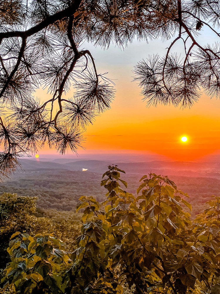
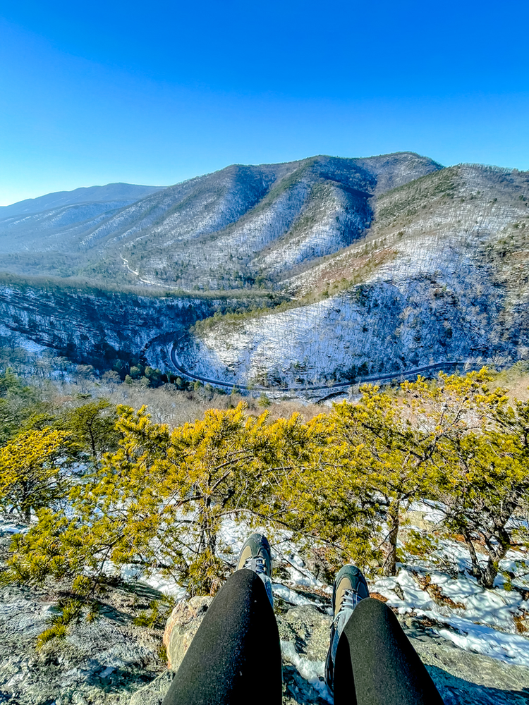
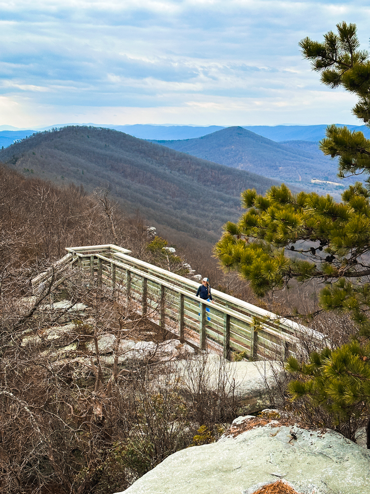
1. Bears Den

Location: Bluemont, VA
Distance from DC: 45 minutes to 1 hour
Hike Distance: 1.5 miles
Elevation Gain: 300 ft
Difficulty: Easy
Bear’s Den is an ideal spot for Northern Virginia and DC locals looking to enjoy a stunning sunset without venturing too far. This brief out-and-back hike covers just 1.5 miles and follows a portion of the Appalachian Trail, gaining only 300 feet in elevation — making it a perfect choice for all skill levels, even families with kids. The overlook faces west, offering breathtaking views of the Shenandoah Valley and Blue Ridge Mountains. Be sure to watch your step, as the path includes plenty of rocks and tree roots along the way.
It’s a great pick for a peaceful weekday evening hike, or you can turn it into a full weekend outing by exploring the area’s many nearby wineries.
🍻 Post-hike tip: Swing by Bear Chase Brewery afterward — they serve both local brews and food!
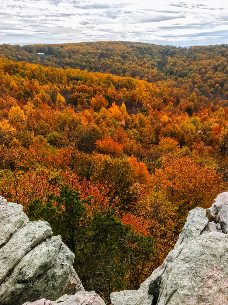
2. Raven Rocks

Location: Bluemont, VA
Distance from DC: 45 minutes to 1 hour
Hike Distance: 5.7 miles
Elevation Gain: 1,550 ft
Difficulty: Hard
Also nestled in Bluemont, Raven Rocks is the tougher counterpart to Bear’s Den. This hike along the Appalachian Trail offers a serious workout, with rocky terrain and several steep inclines. Locals even nickname this part of the trail the “roller coaster” due to its constant ups and downs over the ridgelines. Combine that with a few stream crossings, and it’s no surprise this one earns a “hard” rating on AllTrails.
Make sure to wear sturdy hiking boots, pack plenty of water and snacks, and give yourself enough time to enjoy the challenge. The panoramic view from the top is well worth the effort—especially during fall, when the landscape transforms into a breathtaking canvas of autumn colors. It's easily one of the top fall hikes in Virginia.
🍻 Post-hike tip: Grab a drink and bite at Bear Chase Brewery nearby, or head a bit further to Purcellville, VA for local favorites like Adroit Theory, Belly Love Brewing, or a hearty meal at Monk’s BBQ.
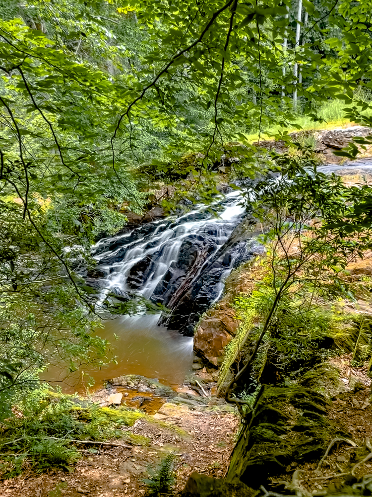
3. Prince William National Forest Park

Location: Triangle, VA
Distance from DC: 45 minutes
Hike Distance: Varies
Elevation Gain: Varies
Difficulty: Easy to Moderate
Located in Triangle, VA near Quantico, this hidden gem is the largest protected green space in the DC metro area. Spanning over 15,000 forested acres, the park features 37 miles of hiking trails and 21 miles of biking trails, plus options for camping and cabins.
For a scenic and peaceful hike, try piecing together a few shorter trails. One great option starts at the visitor center: follow the Laurel Loop, connect to the South Valley Trail, then take the North Valley Trail to reach Quantico Falls. After you reach the cascades, carefully cross the creek and continue along a slightly rugged path—you’ll hear the waterfall before you see it! This out-and-back route is about 2.5 miles, or you can create a longer loop using the trail map available at the visitor center.
Note: There’s a $20 entrance fee per vehicle, or you can use an Annual National Parks pass.
🍻 Post-hike idea: Make your way to nearby Woodbridge and unwind at Brew Republic or Waters End Brewery.
4. Annapolis Rock (and Black Rock)

Location: Boonsboro, MD
Distance from DC: About 1 hour
Hike Distance: 5.0 miles out and back
Elevation Gain: 797 ft
Difficulty: Moderate
This well-loved trail in South Mountain State Park is a favorite for DC-area hikers, thanks to its scenic views and relatively easy access. The trail begins with a steady, gradual incline that leads you up to the ridgeline, followed by a relaxing stretch through the woods.
At the overlook, you’ll be rewarded with sweeping views of Greenbrier Lake below and Black Rock Cliff in the distance. It’s a fantastic hike during summer and especially in the fall when the foliage is at its peak. Since the overlook faces west, it’s also an ideal spot for catching the sunset.
Bonus: If you’re feeling up for more, continue the hike up to Black Rock summit for additional views!
🍻 Post-hike idea: Grab a drink at Elder Pine Brewing or Lone Oak Farm Brewing nearby to wrap up the day.
5. Scott’s Run River Trail to Scott’s Run Falls

Location: McLean, VA
Distance from DC: ~30 minutes
Hike Distance: 1.5 miles
Elevation Gain: 150 ft
Difficulty: Easy
Just off I-495 and tucked near Great Falls Park, this peaceful escape in McLean is ideal when you're short on time or just want a low-effort nature fix. What makes Scott’s Run special is its rare biological ecosystem, which adds a cool twist to your typical woodland hike.
From the nearby parking lot on Georgetown Pike, you’ll have quick access to the trail that leads to a charming waterfall. The hike to the falls is only about 0.75 miles one way, with a brief but steep uphill/downhill section right before the falls. Watch your step during the stream crossings—they can get a bit tricky in colder months!
If you’re up for a little extra, follow the path to the right of the waterfall to walk along the Potomac River. About 0.3 miles ahead, you’ll reach Stubblefield Falls—a lovely, lesser-known cascade.
🍻 Post-hike idea: Swing by Tysons Corner and grab a drink at Tysons Biergarten or head to the top of the Capital One building to check out Starr Hill Brewery.
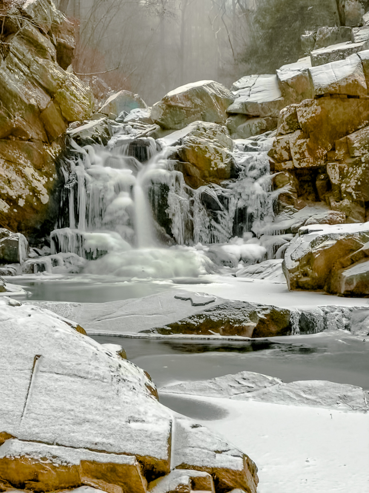
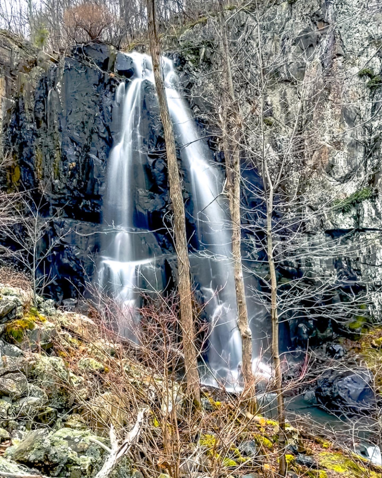
6. Cunningham Falls Nature Trail

Location: Thurmont, MD
Distance from DC: 1 hour
Hike Distance: 2.5 miles
Elevation Gain: 413 ft
Difficulty: Moderate
Located just an hour outside DC, Cunningham Falls State Park is perfect for a refreshing outdoor escape. The star attraction here is Cunningham Falls—standing at 78 feet, it’s the tallest cascading waterfall in Maryland.
This hike is a favorite among locals, especially since it’s not too tough and offers a big payoff. Try visiting on a weekday or early on the weekend to beat the crowds. If you're in the mood for more trail time, there are plenty of paths to explore in the park. And if you're seeking a tougher workout, Catoctin Mountain Park is just around the corner.
🍷 Post-hike idea: Unwind with a glass of wine at Springfield Manor Winery & Distillery in Thurmont, or swing by Frederick to try some local brews at Idiom, Rockwell, or Olde Mother Brewing.
7. Weverton Cliffs

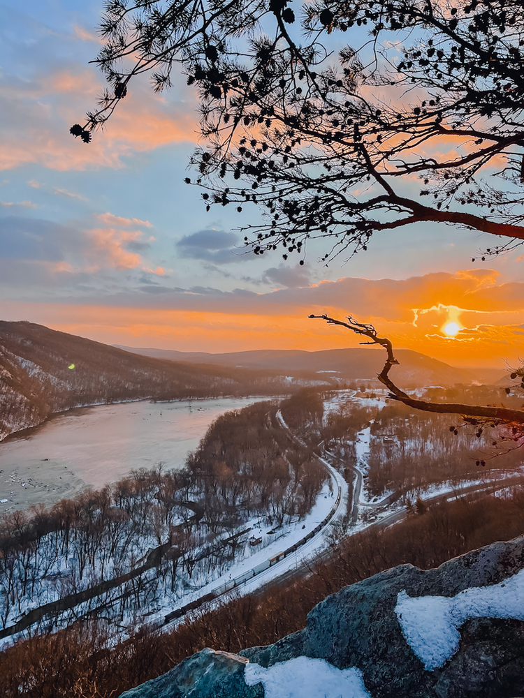
Location: Knoxville, MD
Distance from DC: About 1 hour
Hike Distance: 1.9 miles
Elevation Gain: 567 ft
Difficulty: Moderate
If you're looking for a short but rewarding hike, this one near Knoxville is a gem. The overlook gives a stunning view of the Potomac River—and if you're lucky, you might even catch a train passing below for that extra cinematic touch. It’s perfect for sunrise or sunset, and thanks to the low mileage, you don’t have to worry much about hiking in the dark.
Though it’s under 2 miles round-trip, don’t underestimate it—there are some steep switchbacks and rocky patches that add to the challenge. If you're in the mood for more, you can easily hop onto the Appalachian Trail at the top and continue along the ridgeline.
🍻 Post-hike idea: Kick back at Harpers Ferry Brewing just down the road. Or, if you're up for a short drive, check out the amazing brewery scenes in Frederick, MD or Vanish Farmwoods Brewery in Leesburg, VA.
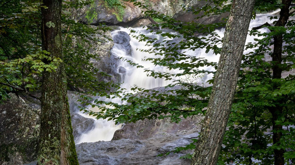
8. Great Falls Park

Great Falls via Difficult Run
Hike Distance: 4.1 miles
Elevation Gain: 400 ft
Difficulty: Moderate
This is the perfect nearby trail when you want something low intensity but still scenic. The River Trail follows the Potomac and provides stunning views of Mather Gorge. After around 2 miles, you'll hit a fork that leads to Difficult Run. This part is quieter and winds along a picturesque stream with a few lovely small waterfalls. You can park at either the main Great Falls lot or the Difficult Run entrance. Personally, I think the Virginia side has the best views of the falls!
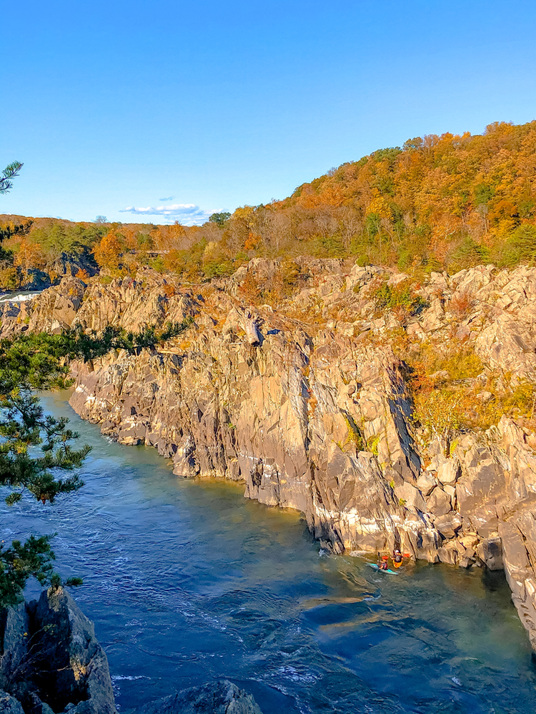
Billy Goat Trail (Note: Trail Closed as of 1/16/23)
Hike Distance: 7.2 miles
Elevation Gain: 249 ft
Difficulty: Moderate
Arguably the most popular trail at Great Falls, the Billy Goat Trail is a favorite among locals. It’s just challenging enough for a fun weekend hike without being overwhelming. The trail hugs the Potomac River and includes sections where you'll need to scramble over rocks, with some people even climbing. This loop takes you through Billy Goat Trail Sections A, B, and C, looping back via the C&O Canal Trail. Even though the hike might not seem too tough on paper, it can be pretty tiring, especially in the summer. Be sure to check for trail closures before heading out, as sections are sometimes closed for repairs.
🍻 Post-hike: After your hike, head to Tysons Corner (see #5 above for brewery options), or visit Old Anglers Inn, located just outside the park, for a great meal.
9. Harpers Ferry via Maryland Heights


Location: Harpers Ferry, WV
Distance from DC: 1.25 hours
Hike Distance: 4.6 miles
Elevation Gain: 1,100 ft
Difficulty: Moderate
Harpers Ferry, located at the meeting point of three states (West Virginia, Maryland, and Virginia), is not only a beautiful town but also historically significant. It was the northernmost point of Confederate territory during the Civil War, a crucial location strategically for the South. The town’s railroad was famously disabled by Stonewall Jackson for nearly a year, preventing Union forces from entering. The first rail bridge over the Potomac was built here in 1836 after the ferry service ended in 1824. With its charming streets, historic sites, and quaint shops and restaurants, Harpers Ferry makes for an excellent day trip from DC.
The hike to the Maryland Heights Overlook is considered moderate, with over 1,000 feet of elevation gain packed into a relatively short distance. After parking (if you’re lucky to find a spot), you’ll cross the bridge into Harpers Ferry Road, where you'll get a great view of the railroad tunnel. From there, take the C&O Canal Trail for a short distance until you reach the trailhead. The path up is mainly uphill and includes some rocky and steep sections. Pace yourself and watch your step. The reward at the top is a stunning view of the town below, and I especially love the sight of the old bridge ruins to your left.
🍻 Post-Hike: After the hike, head to Harpers Ferry Brewing for a refreshing craft beer. Set in a scenic location on a hillside with a beautiful view of the river, it’s the perfect spot to relax.
10. Buzzard Rock

Location: George Washington National Forest (Front Royal, VA
)Distance from DC: 1.5 hours
Hike Distance: 3.8 miles (out and back)
Elevation Gain: 700 ft
Difficulty: Moderate
Buzzard Rock offers a relatively short hike that’s well worth the effort. This trail showcases stunning views throughout the year, but the snow in winter adds an extra layer of magic! The most challenging part of the hike comes in the last mile, where the trail gets steeper, and you’ll have to navigate rocks to reach the ridgeline. Once there, you’ll walk along the ridge for a bit before reaching the massive rock slabs at Buzzard Rock, where you can watch hawks, falcons, and even bald eagles soaring above. The trail continues along the ridge, eventually merging into the Tuscarora Trail. If you're up for more adventure, nearby hikes like Meneka Peak and Signal Knob will challenge you further.
🍻 Post-Hike: Once you’re done, head into Front Royal, VA, where you’ll find plenty of great spots to unwind. I recommend checking out Front Royal Brewing Company (which also serves food), Honey and Hops Brew Works (a meadery), or The Apple House in Linden, famous for its BBQ and apple cider donuts.
11. Mason Neck State Park

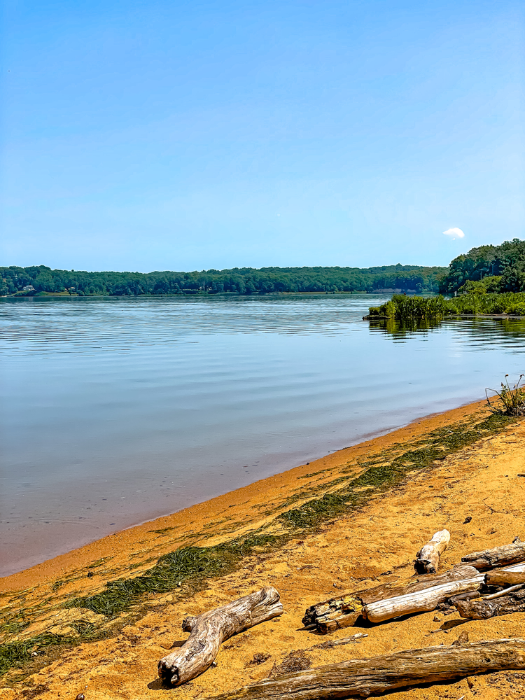
Location: Lorton, VA
Distance from DC: 1 hour
Hike Distance: 1.3-mile loop
Elevation Gain: 68 ft
Difficulty: Easy
Mason Neck State Park is a true gem in Northern Virginia. On a quiet summer weekday, the park is wonderfully serene, with still waters and hardly anyone around. Situated on a peninsula surrounded by Pohick Bay, Belmont Bay, and the Potomac River, this park is perfect for kayaking or stand-up paddleboarding (SUP). It’s also a wildlife haven! The park features several easy trails, including the scenic Bayview Trail, a boardwalk that winds through the marsh. Birdwatching enthusiasts will love it here, as the park is home to bald eagles, great blue herons, and osprey. We even spotted an owl during our visit! For families, there’s a visitor center, a playground, a beach area, and numerous picnic spots to enjoy.
🍻 Post-Hike: After your hike, head over to Fair Winds Brewing Company for a refreshing beer to unwind.
12. Compton Peak via the Appalachian Trail

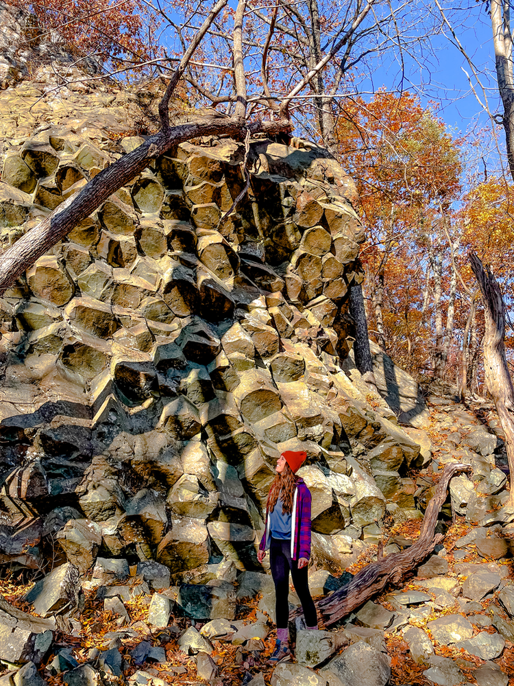
Location: Bentonville, VA
Distance from DC: 1.5 hours
Hike Distance: 2.3 miles out and back
Elevation Gain: 705 ft
Difficulty: Moderate
Compton Peak is a must-do if you’re looking for a short, rewarding hike near DC. Located just 10 miles from the Front Royal entrance of Shenandoah National Park, it’s one of the closest summit hikes in the park—and easily one of the most unique. While the view from the summit of Compton Peak is lovely, the real showstopper is the ancient columnar basalt formations along the trail. These geometric rock formations, formed by lava flows cooling and fracturing over 800 million years ago, resemble the famous Giant’s Causeway in Ireland. It’s a fascinating blend of geology and natural beauty packed into a quick hike that’s perfect for a day trip.
🍻 Post-Hike: After your hike, head into Front Royal for a bite and a brew—see the options listed under number 10!
13. Mary’s Rock (Northern Approach)

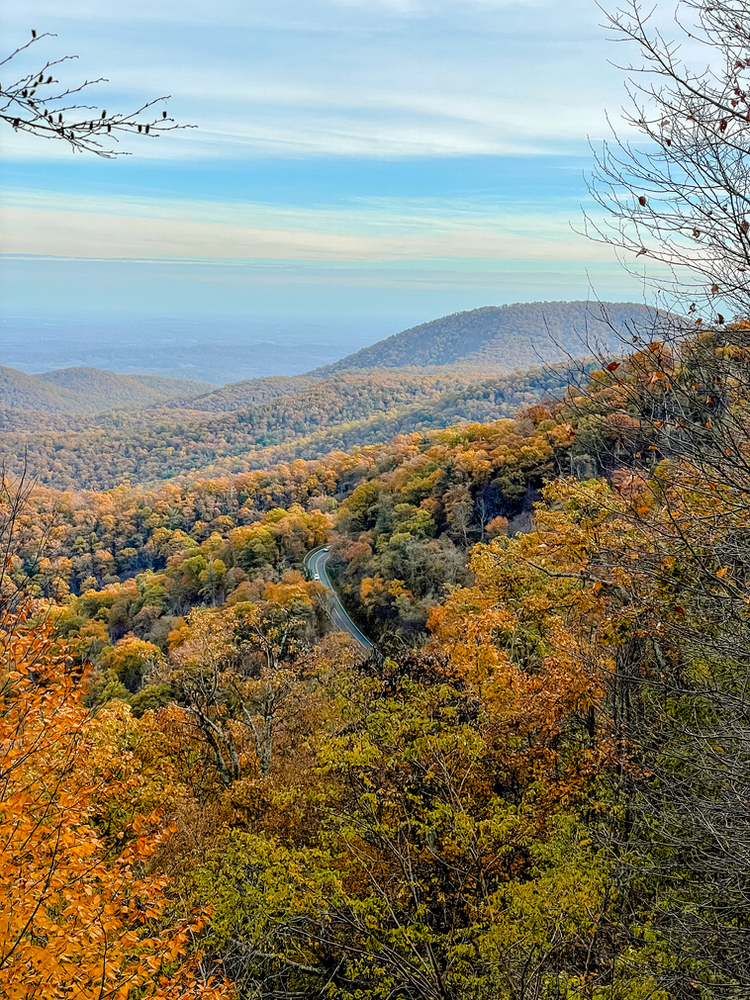
Location: Sperryville, VA
Distance from DC: 1.5 hours
Hike Distance: 3.4 miles out and back
Elevation Gain: 1,200 ft
Difficulty: Moderate
Mary’s Rock is a Shenandoah classic—and for good reason. Whether you tackle it via the popular Northern Approach from the Panorama parking lot or the longer, scenic route from the Pinnacle Picnic Area, you’re in for sweeping Blue Ridge views and a satisfying climb. The summit puts you roughly 1,000 feet above the Thornton Gap entrance and offers epic vistas of the surrounding valley. You’ll also find a few rocky outcrops at the top that are fun for a little scrambling. While the trail is beautiful year-round, it’s especially magical during peak fall foliage (early November is a sweet spot).
If time allows, don’t miss Mary’s Rock Tunnel—the only tunnel in Shenandoah National Park and a cool piece of park history.
🍻 Post-Hike: Refuel in Sperryville at Headmasters Pub (think 80s arcade meets pub fare) or sip on wild-fermented brews at Pen Druid Brewing in their laid-back outdoor space.
14. Big Schloss via Wolf Gap

Location: Lost City, WV (George Washington National Forest)
Distance from DC: ~2 hours
Hike Distance: 4.3 miles out and back
Elevation Gain: 1,046 ft
Difficulty: Moderate
Tucked away near the VA/WV border, Tibbet Knob is a lesser-known gem in George Washington National Forest. Often overshadowed by neighboring Shenandoah, this trail offers a refreshing escape from the crowds. The climb starts steep, with most of the elevation gain happening early, but once you hit the ridgeline, the trail evens out and rewards you with sweeping views nearly the whole way. Expect a wooden bridge crossing, a bit of rock scrambling near the summit, and an almost 360° payoff at the top. It’s especially magical with a dusting of snow!
Bonus: The trailhead at Wolf Gap Campground has restrooms—a rare luxury for trailheads in the region.
🍻 Post-Hike: Make your way to nearby Woodstock, VA, a charming small town with big flavor. Check out Woodstock Brew House for hearty eats and a cold pint, or swing by Woodstock Cafe for cozy vibes and good coffee.
15. Overall Run Falls via Thompson Hollow

Location: Bentonville, VA
Distance from DC: 1.5 hours
Hike Distance: 2.1 miles out and back (to Blue Hole) or 6.3 miles out and back (to Overall Run Falls)
Elevation Gain: 390 ft (to Blue Hole) or 1,400 ft (to Overall Run Falls)Difficulty: Moderate to Hard
This trail offers two adventures in one! From the Thompson Hollow Trailhead, the short 1-mile hike each way leads to Blue Hole, a scenic series of cascading waterfalls and refreshing blue pools—perfect for a summer escape. Though it's not a long hike, trail intersections near the pools can be confusing, so it’s best to have AllTrails handy to stay on course.
Want a challenge? Continue your hike upward to reach Overall Run Falls, the tallest waterfall in Shenandoah National Park at 93 feet! The added distance and elevation gain make this route a solid workout with an epic payoff.
Important: Parking is very limited at Thompson Hollow and strictly enforced. Only park in designated areas to avoid tickets or towing.
🍽️ Post-Hike:If you're heading back north, stop by Front Royal for food and drinks (see recommendations above). Going south? Don’t miss Hawksbill Brewing Company in Luray, VA—a perfect spot to unwind after a day on the trail.


Comments